

The successful orbital insertion of EO-2 on February 12, 2026, marks a transformative juncture in Pakistan’s sixty-five-year journey within the space domain. As the second indigenously engineered electro-optical satellite deployed in just over a year, EO-2 epitomizes Pakistan’s evolution from a consumer of foreign satellite services to a nation capable of sustaining sovereign orbital infrastructure. This trajectory, beginning in the nascent years of the Space Age, reflects the interplay of scientific ambition, geopolitical shifts, institutional restructuring, and a resolute drive toward technological self-reliance. SUPARCO, the central architect of this progress, has consistently balanced the dual imperatives of national development and strategic autonomy, positioning space capability as a cornerstone of governance, climate resilience, and defence preparedness.
The Genesis of Space Exploration (1961–1972)
Pakistan’s entry into space research positioned it as a pioneer among developing nations. The vision of Dr. Abdus Salam and Dr. Ishrat Usmani catalyzed the establishment of SUPARCO on September 16, 1961. Initially tasked with upper-atmosphere research and rocketry development, SUPARCO embarked on a mission that combined scientific curiosity with strategic foresight.
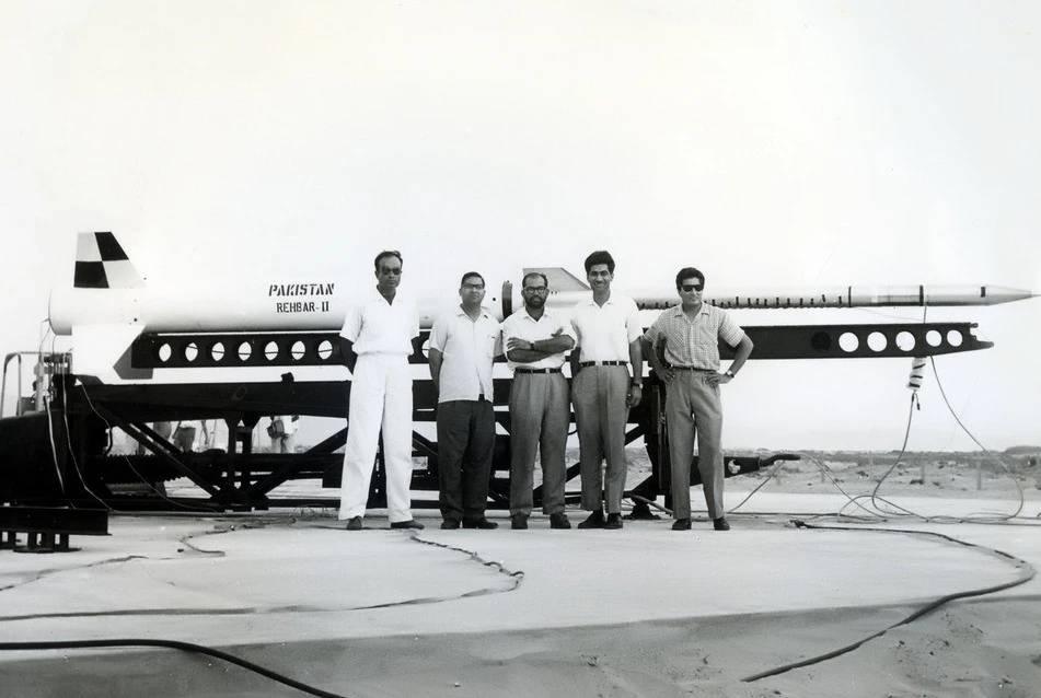
The launch of Rehbar-I on June 7, 1962, from Sonmiani Flight Test Range heralded Pakistan’s arrival on the space frontier. Using a Nike-Cajun two-stage rocket supplied by NASA, the mission achieved an altitude of 128 km, making Pakistan the first South Asian nation to launch a sounding rocket. Subsequent launches throughout the 1960s, supported by the United States and France, generated vital data on atmospheric physics and established early expertise in telemetry and rocketry. By 1972, more than 200 sounding rockets had been launched.
Institutional Reorganization and Early Satellite Missions (1981–2001)
The 1981 reorganization of SUPARCO as an independent federal commission signalled Pakistan’s commitment to satellite technology. The Badr program, encompassing Badr-1 and Badr-B, provided foundational “learning by doing” experiences in satellite design, telemetry, and Earth observation. Badr-1’s successful launch from China in 1990 established Pakistan as a satellite-faring nation, while Badr-B’s experimental sensors laid the groundwork for remote sensing capabilities. Integration under the Strategic Plans Division (SPD) in the late 1990s aligned space assets with national security priorities, ensuring secure communications and surveillance while also imposing a disciplined, hierarchical framework that influenced innovation dynamics.
Communication Satellites and Geostationary Ambitions
The PakSAT program has been central to Pakistan’s communications infrastructure. From PakSAT-1 in 1996 to PakSAT-1R (2011) and PakSAT-MM1R (2024), Pakistan has secured geostationary slots critical for high-speed internet, e-governance, and secure communications. These platforms are indispensable for national development, bridging digital divides, and enabling strategic resilience.
The Rise of Earth Observation (2018–2026)
Recent years have witnessed a strategic pivot toward Earth Observation (EO) to address climate vulnerability, urban sprawl, and disaster management. The launches of PRSS-1 and PakTES-1A in 2018 marked the transition to high-resolution imaging and indigenous satellite production. The 2024 iCube-Qamar lunar mission demonstrated Pakistan’s entry into deep space, capturing lunar imagery and validating long-distance communication systems, reflecting both international collaboration and home-grown technical proficiency.
Indigenous Electro-Optical Satellite Surge (2025–2026)
A new era began with the launch of PRSC-EO1 in January 2025, the first fully indigenous electro-optical satellite. It enabled precision monitoring of agriculture and urbanization. PRSS-2 and HS-1 further expanded Pakistan’s capabilities in disaster response, hyperspectral analysis, and environmental monitoring. The EO-2 launch on February 12, 2026, solidifies a tandem satellite architecture with EO-1, delivering sub-meter resolution imagery and rapid revisit capabilities. This “quasi-constellation” strengthens geospatial autonomy, providing critical intelligence for infrastructure mapping, urban planning, and strategic surveillance.
Strategic Framework: Vision 2047 and the National Space Policy
The National Space Policy 2024 and “Space Vision 2047” define an ambitious roadmap: five GEO satellites, six LEO satellites, indigenous launch vehicles, manned spaceflight, and deep-space missions. PSARB ensures regulatory governance while fostering a private-sector space ecosystem. Space technology serves as a national resilience tool, supporting agriculture, water management, urban governance, and disaster mitigation. By integrating satellite data with AI and geospatial analytics, Pakistan is leveraging space to transform development planning, strategic deterrence, and environmental management.
Conclusion
Pakistan’s space odyssey reflects intellectual ambition, strategic foresight, and technological perseverance. SUPARCO’s journey from sounding rockets to the EO-2 constellation underscores the nation’s emergence as a regional space power. In a world where space is both a frontier of opportunity and strategic necessity, Pakistan’s continued ascent affirms that the sky is no longer a limit but a domain where innovation, resilience, and sovereignty converge.